|
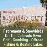
| The area from I-10 in Quartzsite to Bullhead City via U.S. 95 is a paradise for nature lovers and sun seekers. Quartzsite is a paradise for rock hounds, with agates, quartz, limonite cubes, even gold is found in the area. Scenic views are everywhere, state parks are all along the river, wildlife refuges offer birding opportunities, and river offers all types of water sports. |
| Quartzsite |
 |
Quartzsite was established in 1867 on the site of Old Fort Tyson. Historic and scenic areas include Crystal Hill, Tyson Tanks, Tyson Wells Museum and the Hi Jolly Monument, Castle Dome Peak.
Quartzsite, Arizona is considered the "Meeting Place" in the winter for thousands of RVers. Each winter Quartzite swells in population due to well over a million visitors, most of whom converge on the small town in a wave of RVs during the winter months. This is true Arizona snowbird country
Not since they began recording in 1959 has there been any snow ever recorded falling in this area. In the summer you will only see flat desert, some roadside businesses, tumbleweeds and wide open spaces.
A Quartzsite special attraction is that it has been a rock-hound's paradise since the 1960's. Eight major gem and mineral shows as well as vendors of raw and handcrafted merchandise peddle their wares to snowbirds, collectors and enthusiasts. The town hosts an annual rock and mineral show that attract more than 850,000 people.
|
|
Annual Hobby, Craft and Gem Show |
|
Annual Sports, Vacation & RV Show |
|
Annual Quartzsite Rock and Roll Classic Car Show |
|
| Parker |
|
Parker, Arizona located along the Mighty Colorado River, features year round fun and activities for young and old. Recreational boating and swimming during summer along with OHV trails and off-road racing in winter just to name a few. Specialized local shops and a variety of dining and lodging choices make Parker a "gem" of western Arizona.
Created between Parker Dam, the world’s deepest dam and Headgate Rock Dam, this boating capital of the Southwest offers as much water fun as you can handle. Jet ski, water skiing, canoeing, camping and great fishing. And when you get hungry, just pull-up to the many waterfront establishments.
Each year the community hosts an international inner tube race in mid-June. It attracts hundreds of dedicated tubers, who travel along the 7 miles in a variety of outlandish outfits.
|
|
Parker, AZ Official Website |
|
Arizona Information - Parker Vacations & Boating |
|
| Buckskin Mountain State Park |
|
Buckskin Mountain State Park commands one of the finest views along the Parker strip, an 18-mile stretch between Parker Dam and Headgate Dam. Mountains line the river on both the Arizona and California sides, and the wildlife is as varied as the recreational opportunities along the river. This picturesque park provides a scenic respite, mountain hikes, a desert escape and fun-filled water adventure. |
|
Official Buckskin Mountain State Park Website |
|
| Parker Dam |
|
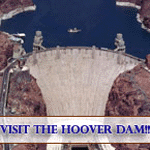
| Parker Dam spans the Colorado River between Arizona and California 17 miles northeast of the town for which it is named.
Built between 1934 and 1938 by the Bureau of Reclamation, Parker Dam is one part of a system of storage and diversion structures built by Reclamation to control and regulate the once unruly Colorado River.
|
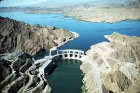 |
| Parker Dam's primary purpose is to provide reservoir storage from which water can be pumped into the Colorado River (California) and Central Arizona Project Aqueducts. Lake Havasu, the reservoir behind Parker Dam, is about 45 miles long and covers nearly 20,390 acres. It can store 648,000 acre-feet or nearly 211 billion gallons of water. |
| Lake Havasu Information |
|
|
| Bill Williams River - National Wildlife Refuge |
|
| With its majestic rock cliffs; its ribbon of cool water running through classic Sonoran Desert; and its cattail-filled marsh harboring rails and waterfowl, Bill Williams River National Wildlife Refuge offers a little bit of everything for both wildlife and people.
Bill Williams River NWR holds one of the last stands of natural cottonwood-willow forest along the lower Colorado River, creating a unique ecosystem that provides good habitat for resident and migratory wildlife.
The rare riparian habitat of Bill Williams River NWR draws a variety of neotropical migratory birds—winging their way from Central and South America to their breeding grounds in the north. Bright colors from birds like the yellow warbler, vermillion flycatcher, and summer tanager flash like sparks in the desert sky as they flit across the riverbed. Official Website
|
|
|
| Cattail Cove State Park |
|
Cattail Cove State Park offers you and your family a chance to get away and enjoy tranquility along Lake Havasu. The 2,000-acre park offer a broad spectrum of activities for all to enjoy. Whether you're interested in swimming, fishing or just lounging and relaxing.
The 45-mile long lake creates a haven for all kinds of water sports. Fish for largemouth and striped bass, channel & flathead catfish, bluegill and crappie. Boat on the blue waters, sail into quiet coves, or water ski or jet ski out on the open lake.
The area surrounding the park is also a rock hound's paradise. Volcanic rock, geodes, jaspers, obsidian, turquoise and agate can be found outside Lake Havasu City.
|
|
Official State Park Website |
|
| Lake Havasu State Park |
|
Lake Havasu State Park offers many water recreation activities. Located within Lake Havasu City, it is a great place to spend the day. The scenic shoreline is an ideal place to enjoy beautiful beaches, nature trails, boat ramps, and convenient campsites. This spot is truly a watersport haven located near the famous London Bridge of Lake Havasu City.
The park offers 3 boat ramps, 47 campsites, picnic area, and beach area. The Mohave Sunset Trail (1.5 miles) winds its way through the lowland desert and along the shoreline.
|
|
Lake Havasu State Park Official Website |
|
| Lake Havasu City |
|
Lake Havasu City, established in 1963, was designed as a self-sufficient, planned community for several thousand residents. Although somewhat isolated from the rest of the state, it continues to attract newcomers and is growing into an attractive community for people who love a quiet, water-recreation lifestyle. It is especially popular with Southern Californians as a weekend destination during the summer.
|
|
More Information about Lake Havasu City |
|
|
|
|
|
|