 |
|
| The roadtrip from Phoenix to Flagstaff has many beautiful vistas. Interstate 17 is an easy drive as it climbs from the Valley Of The Sun up the Mogollon rim to the high forest country. North of Black Canyon City on I-17 there is a rest stop that has been rated one of the most beautiful in the country. I-17 is one of Arizona's two Interstates that do not go between states. |
| Phoenix |
 |
Phoenix is an agricultural, industrial and service center. It is surrounded by 22 other cities in the Valley of the Sun where western style homes and sprawling shopping malls abound. There is exhilarating adventure, breath-taking golf courses, trendy shopping, modern nightlife and enriching culture. |
|
Additional Information about Phoenix |
|
| Anthem |
|
 Anthem is the result of a Del Webb development on a large parcel of land adjacent to the town of New River, Arizona, United States. Although Anthem is currently unincorporated, Phoenix is slated to annex the community by 2020 as documented in the City of Phoenix General Plan. Anthem has grown substantially since its founding and now has an estimated population of about 40,000 people. Anthem is the result of a Del Webb development on a large parcel of land adjacent to the town of New River, Arizona, United States. Although Anthem is currently unincorporated, Phoenix is slated to annex the community by 2020 as documented in the City of Phoenix General Plan. Anthem has grown substantially since its founding and now has an estimated population of about 40,000 people.
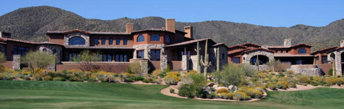
Featuring sweeping mountain vistas, golf, hiking and other recreational opportunities, Anthem has been described as one of the best places to live in Arizona by Phoenix Magazine and the best place to raise a family by Parenting Magazine in November 2003. It is a great place to live. The Anthem Country Club is shown above. |
|
| Black Canyon City |
|
Black Canyon City is in Yavapai County. The town is situated near the Bradshaw Mountains, along the Agua Fria River below Black Mesa in Black Canyon. It is a small town that began as a stage stop between Phoenix and Prescott.
The name Black Canyon City can be misleading for it is not an incorporated city. The community offers opportunities for new businesses and a great place for winter tourists to use as a refuge. Black Canyon City is the only town on I-17 with a business bypass.
Today Black Canyon City’s population is 4,000. The town sits at an elevation of 2,000 feet. Black Canyon City has smog-free, sunny weather throughout the year. The warm desert climate has a winter low temperature of 40 degrees and a summer high temperature of 103 degrees. |
|
Tonto National Forest |
|
| Agua Fria National Monument |
|
The 71,100 acre Agua Fria National Monument has ancient ruins that offer insights into the lives of those who long ago inhabited this part of the desert Southwest. The monument encompasses two mesas, Perry Mesa and the adjacent, smaller Black Mesa, the public land to the north of these mesas, and the canyon of the Agua Fria River.
Elevations range from 600 feet above sea level along the Agua Fria Canyon to about 4,300 feet in the northern hills. At least 450 prehistoric sites are known to exist within the monument, and there are likely many more. Many intact petroglyph sites within the monument contain rock art symbols etched into the surfaces of boulders and cliff faces. |
|
Agua Fria National Monument Government Websites |
|
| Cordes Junction - Arizona Highway 69 |
|
Cordes Junction is the interchange of Interstate I-17 and State Route 69 which leads to Mayer and Prewscott. The community features gently rolling land and panoramic mountain views. The elevation ranges from about 3500 to 4000. The Arizona Highway 69 Area consists of several small communities including Dewey-Humboldt, Mayer, Spring Valley, Cordes Lakes, Cordes Junction and Poland Junction. |
|
| Camp Verde |
|
Camp Verde has a small town atmosphere, a friendly, relaxed, no-pressure way of life where practically everyone knows each other. Wide-open spaces, the Verde River, a mild 4-season climate and panoramic views from the vistas above the valley makes it a rare and enviable location among Arizona cities and towns.
The climate is arid, the hot summer days are often cooled by monsoons rains and the winters are mild. Camp Verde's valley floor is classified as Lower Sonoran Desert.
Camp Verde, the oldest settlement in the Verde Valley, settled in February 1865 and is the home of a historic military post, Fort Verde State Park. Many people pass through on the way to Cottonwood and Sedona. |
|
Fort Verde State Park |
|
Montezuma Castle National Monument |
|
| Junction of Arizona 179 to Sedona |
|
One of Arizona's most popular getaways is Sedona via Interstate 17 and Arizona 179. Take Arizona 179 to Sedona and keep an eye out for the famous red rocks for which the town is known. Iron oxide in the rock gives the landscape its fiery hue. SR 179 is designated as an All-American Road due to the sandstone formations through which it travels along its 7.5-mile (12.1 km) length |
|
Prescott National Forest is comprised of about 1.25 million acres. The Prescott borders three other National Forests in Arizona: Kaibab, Coconino, and Tonto. Roughly half of the forest lies west of the city of Prescott, Arizona, in the Juniper, Santa Maria, Sierra Prieta, and Bradshaw Mountains. The other half of the Forest lies east of Prescott and takes in the Black Hills, Mingus Mountain, Black Mesa, and the headwaters of the Verde River. |
|
Prescott National Forest |
|
| Kachina Village |
|
Kachina Village is a small community located six miles south of Flagstaff, Arizona on Interstate 17. It is a beautiful place to live. As of 2007, Kachina Village's population is 2,974 people.
The median home cost in Kachina Village is $575,000. Kachina Village has many types of homes. There are seasonal homes, year round homes, investment property, which includes cabins, traditional homes, non traditional homes, mobile and manufactured homes. Lot sizes, range from 5000 sq. ft. to 10 acres. |
|
| Flagstaff |
|
Flagstaff is a community rich with cultural diversity, beauty, and history as well as amazing educational, recreational and scientific opportunities. At 7,000 feet elevation, Flagstaff is considered a high altitude semi-desert location. Flagstaff known as the city of pines has four different seasons making it a perfect location for tourist attraction. |
|
Additional information about Flagstaff |
|
| Click Here For More Arizona Highway Guides |
| Tell A Friend About ArizonaHighwayGuides.com |
 |
| |
|
|
|
|
|