- Page 2 - Page 2 |
| Winslow |
|
Winslow, at an altitude of 5,500 feet, grew from a wagon trail to an Atlantic & Pacific Railway terminal in 1881. The advent of the automobile further enlarged the town, making Winslow a major stopping point for travelers. Old Route 66 came right through and brought many visitors. Today I-40 does the same. Winslow is timeless... in touch with the past, in tune with the future. |
|
|
|
| The "Standin’ on the Corner" Park -
Located in downtown Winslow is "The Corner", made famous by the song "Take It Easy". Written by Glenn Frey and Jackson Browne, "Take It Easy" became The Eagles first hit single in the 70's, and peaked peoples interest in Winslow. There is a life size bronze statue and a two story mural depicting the story behind the famous song. |
 |
|
 |
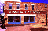
Historic La Posada Hotel - This magnificent property, designed by renowned architect Mary Colter, is the last of the great Harvey Houses of the 1930's. Mary Colter was the premier southwest architect of the early 1900's. She herself referred to the La Posada Hotel in Winslow as her masterpiece.
As the showplace of the entire Santa Fe Railroad system, all passenger trains running between Los Angeles and Chicago stopped at the La Posada. Unfortunately, many of the great hotels designed by her and others are gone, but not in Winslow.
The Hotel has been beautifully restored and is in full operation! Enjoy strolling the beautiful gardens of the hotel while viewing this outstanding example of southwestern architecture. La Posada Hotel
Old Trails Historical Museum - The museum is located in a former bank building in downtown Winslow that still has its original tile floor, marble counters and vault. The exhibits include artifacts from the “Harvey Girls,” Route 66 and Winslow history. Old Trails Historical Museum
Homolovi Ruins State Park - The park, located three miles northeast of Winslow on Arizona 87, feature ancient Hopi ruins and hikes that wind through the ruins and petroglyphs. The park also offers a view of Little Painted Desert County Park that’s outstanding at sunset. Website
Winslow is an interested place to stop along your journey. The area offers much to see and with reminders of years gone by in forms. You may see Native American women in traditional dress and cowboys right off the range.
|
|
| Joseph City |
|
The town is located just off of Interstate 40, on the old section of Route 66. It is the oldest community in Navajo County. It began as a tiny Mormon community and has grown to a sizable retail trade and service town. Today Joseph City has a population of 1,465. The town sits at an elevation of 5,083 feet. |
|
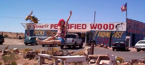
| James Taylor built the Jackrabbit Trading Post in 1949. Over the years it has become a well known landmark, the type of place where it is fun to stop and buy pieces of petrified wood, turquoise jewelry, and Indian souvenirs. |
 |
|
|
| Holbrook |
|
Holbrook, Arizona is a high desert town steeped in Wild West history. In 1882, a railroad station was built at Horsehead Crossing and the town's name was changed to Holbrook in honor of the Atlantic & Pacific Railroad chief engineer, H. R. Holbrook.
Frontiersmen were cowboys, cattle ranchers and railroaders who made Holbrook the center of ranch country.
Before long it was welcoming travelers of Route 66, known as The Mother Road, sometimes called The Main Street of America. First they fled the dust bowl and later returning to country they had seen during World War II.
Today the spectacular beauty and spirituality of Indian Country beckons travelers to pull off Interstate 40. It is a welcoming osasis to come across as you travel the wide expanses of northern Arizona. There are many places to stay, but have you ever slept in a TP? Check out the Wigwam Motel!
|
|
For those who enjoy the beauty of petrified wood, check out Stewart's.
|
|
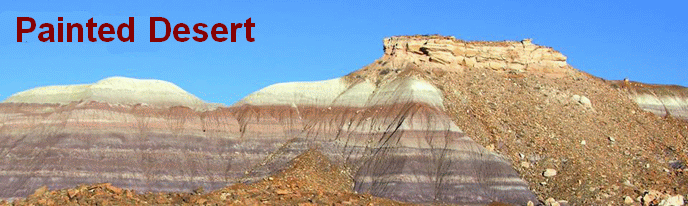
| Painted Desert |
|
Painted Desert is the name for a broad area of badlands located in Northern Arizona gets its name from bands of red, white and yellow sediments and bentonite clay of the Chinle rock formation, exposed by erosion.
The Painted Desert encompasses over 93,500 acres and stretches over 160 miles. It begins about 30 miles north of Cameron, Arizona near the southeastern rim of the Grand Canyon to the Petrified Forest about 26 miles east of Holbrook, AZ. It is a long expanse of badland hills and buttes and although barren and austere, it is a beautiful landscape of a rainbow of colors. Visitor Center Info
|
|
|
|
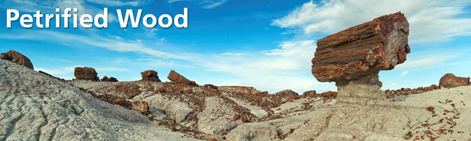
| Petrified Forest National Park |
|
The park contains one of the world’s largest concentrations of petrified wood and best fossil records and rock formations from the Late Triassic period. A driving loop covers the main sites in an hour or two. Removal of the petrified wood or fossils is prohibited. The Painted Desert Inn, formerly a working 28-room inn, has been renovated and now serves as the home for the park’s museum. Park Website |
|
 |
|
| Northeastern Arizona to New Mexico |
This is a region of the U.S. state of Arizona commonly including Apache County and Navajo County. Some notable towns there are St. Johns, Eagar, Holbrook, Show Low, Winslow, Window Rock, Fort Defiance, Ganado, Chinle, and Kayenta.
It is the location of several Indian reservations including all of the Zuni Indian Reservation and most parts of the Hopi Reservation, the Navajo Nation, and the Fort Apache Indian Reservation. The rugged desert landscape of Northeast Arizona has been inhabited by indigenous peoples since at least the construction of what are now the ruins at Monument Valley, Navajo National Monument, and Canyon de Chelly National Monument.
Northeast Arizona is arid, largely free of greenery, and characterized by hills, mesas, buttes, cliffs, and canyons. The windy stony plains of the Petrified Forest National Park exhibits parts of the barren colorful Painted Desert as well as preserved Native American petroglyphs. Northeast Arizona is also home to the Apache-Sitgreaves National Forest and Four Corners Monument. |
|
|